Showing posts with label Island. Show all posts

Sunday, July 12, 2015

Day 5 - Westfjords Waterfalls and Coastal Villages

Amazing Drive through the Westfjords.  Can you see me?
After a somewhat rough start to the Westfjords the day before (see post), we were excited for a fresh start to explore the area.  The adventure included driving winding and remote roads, hiking up an enormous waterfall, and exploring quaint, small towns.  In this wild and remote wilderness, we finally felt more like travelers and less like common tourists.  Here's how to recreate this adventure...

Day 5 - Westfjords Waterfalls and Coastal Villages 
Driving gravel roads up and down the fjords.


Most of the day consisted of driving through winding fjords.  The roads were sometimes paved and sometimes a dirt/gravel combo.  I was intimidated at first - worried that our little 2-wheel drive car wouldn't be able to handle the climbs.  I was wrong.  We stayed on Rt 60 for the most part and found that we could navigate the gravel roads just fine.  Nothing was as bad as the day's prior when we took Rt 614 to the Red Beach (see previous post).

Our first stop from Patreksfjörður was the Dynjandi waterfall.  This impressive series of falls totals a 100 m drop.  Visitors park at the bottom and can walk up to the base of the largest fall.  Bring a rain jacket to avoid spray!  I loved this waterfall - the series of diverse cascades all flowing down toward the fjord is a beautiful and powerful sight which was impossible to capture on camera.

Can you see the person at the base of the top falls?  Dynjandi is huge!
Our next stop was at Hranfnseyri, which Leanne coined the "church and turf".  This quick stop is a tiny, picturesque church sitting next to a turf house. The home has been recreated to represent early Icelandic homes.  There is no charge to tour the house. The site has bathrooms and coffee/pastry available for purchase.
"Church and Turf"

Driving in multi-km one-lane tunnels
We drove on and entered a new Icelandic road type: long and dark, one-lane tunnels.  These tunnels are a marvel.

Driving north through the tunnel on Rt 60, we discovered we had the right-of-way.  Oncoming traffic received a flashing light if cars were approaching and they would have to pull off onto one of the labeled safe zones.  The tunnel went on for multiple kilometers and even included a three-way intersection!


Hotel Edda rooms feel like a dorm...because they are.
The tunnel popped us out in the good-sized town of Ísafjörður. We checked into our Hotel Edda.  We stayed at multiple of these chain hotels over our trip, and I commented that it looked like a dorm room.  It turns out that's because it is one!  Icelandair converts boarding schools into low-budget guesthouses in the summer months and calls them "Hotel Edda".  They provide a reasonable dorm-style room with a shared bath.

In Ísafjörður, we walked through the town and decided to eat at Husio which served American-style meals like burgers and pizza but also had some Icelandic menu items like soup and fish.  After dinner, we walked around town some more and went back to the hotel for an early night in.

On the map, the Westfjords might lack the numerous named sites you find in southern Iceland, but don't let that fool you.  In just a couple days we witnessed hundreds of massive waterfalls, mountains, ice sheets, rare sea birds, and spectacular landscapes that should not be missed.

Just one of the unnamed, "small" waterfalls along our drive.

READ ABOUT THE NEXT DAY HERE:  Day 6 - Westfjords Continued - Hot Tubs, Waterfalls, and Sorcery

Please leave comments or questions below, or visit us on our Facebook page at The Freelance Adventurer for more photos and stories or visit us on Instagram @FreelanceAdventurer.

Saturday, July 11, 2015

Day 4 - Westfjords - Winding Roads, Mountains, Puffins, and a Ferry

Ice and barren landscape driving over the Westfjords.

What should have been a quick day through the fjords began with us being stranded on a small island and ended with midnight sun on puffin-covered, ocean cliffs.  The Westfjords of Iceland are often overlooked by tourists because it is away from the popular Ring Road, and slow winding (and usually gravel-road) driving.  We were fortunate to explore the wild Westfjords by car and ferry.  Below is our adventure...

The Wild Westfjords - Winding Roads, Mountains, Puffins, and a Ferry

The morning started pleasant enough...we got up early and drove to the town of Stykkishólmur to catch our morning car ferry to the Westfjords. The ferry is a three hour voyage - broken up after two hours with a drop off/pick up on the small residential island of Flatey.  The three of us were all under the impression that the ferry spent 30 minutes or so on the island and that we were free to walk around and see it before moving on to our final destination.

Flatey Island Town
At the island, we disembarked to explore with a large group of fellow passengers.  The island is small (2 km by 1 km) with a hotel/restaurant and small shop. We walked down the island for ten minutes before turning around to return to the boat (just to be safe).  When we turned, we saw OUR FERRY in the distance.  It couldn't be!!!  It just couldn't!  Our car!  Our luggage!  Everything was on the ship!  

We ran back to the dock.  There was no one there and sure enough, the ship was gone.  We ran into the shop/coffee shop.  "We are supposed to the be on that boat!"  I said to the teens behind the counter.  They stared blankly back.  An adult shop worker came to our rescue.  She called the ship and found that they would be coming back for one more run that day.  Luckily, our car was parked on the side of the interior, making it possible for the other cars to get around us.  This just meant that we had a two hour wait, followed by a two hour ferry back to Stykkishólmur, followed by a three hour ferry again to Brjánslækur.  Sigh.  It wasn't optimal, but it sure beat stranded on a 2 km island in the North Atlantic for the night!   So this is what we did.  It was a long wait but we eventually got to Brjánslækur.  

Resting Sheep on Flatey Island
We prayed this would be the only mishap we'd have on the trip.  I am extremely grateful to the woman at the Flatey cafe/shop who helped us by contacting the boat and negotiating our return.  I am also extremely grateful to the crew of Seatours who could have easily been furious with us and charged us for our mishap (they didn't even charge us for a second return!) One crewman also sat with us and consoled us on our return.   Two pet peeves of the experience - the boat announced that we would having a short stop at the island but didn't say not to disembark.  AND ... the rude Americans who thought our misfortune was hilarious and then three of them took my photo (without permission) before while laughing and piling into their SUV.  Really?!

Flatey Island
It was such a relief to get off the ferry.  A friendly crewman had spoken to us about a geothermal public hot tub near the ferry landing, in Flókalundur, that was made of rocks on the ocean.  We decided to check it out.  When we arrived, the hot tub was beautiful, but the cold wind and lack of shelter chilled us and we decided not to take the dip.  

We drove on to our hostel in Patreksfjörður called Hostel Radagerdi.  Besides our stay at the Icelandair Hotel, this Hostel was by far our nicest accommodation.  Our room came with a private bathroom (most of our guesthouses did not).  It also had a superb breakfast spread in the morning with French-pressed coffee.  Mmmm.  

After check-in, we decided to see two more sights - the Red Beach and Latrabjarg cliffs.  We didn't realize due to gravel winding roads, this trip would take hours and we wouldn't return until after midnight.

To access Raudassandur (Red Beach), we had to take the windy, gravel, and steep Rt 614 over the fjord to
Check out the road behind me.  This for miles!
the remote beach.  The drive is accessible without 4-wheel drive (we didn't have it), but be careful of the cars that do - they barrel up and down the road and kick up gravel that can crack your windshield (it happened ... a story for another time).  Driving down the mountain, we got a glimpse from above of the gorgeous red sand bar stretching around the fjord. When we made it to the base, we were unable to discover how to access the sandbar offshore by foot without getting soaked.  Perhaps it's best accessed at a low tide?  If any readers have insight, please leave comments.  Either way, we still enjoyed the thrilling drive and the views from above.

Puffins
From the Red Beach, we drove back on Rt 614 and took Rt 612 through more windy roads and sleepy towns to Latrabjarg - a well known seabird nesting area.  We arrived around 10:30 pm.  There was still a small tour bus of bird-enthusiast photographers as well as a couple other cars.  Approaching the high cliff edge, we saw hundreds of razor bills, gulls, puffins, and terns flying and resting on the cliffs.  Some puffins rested near the edge and it was easy to get within 2 feet of a bird.  *Our hostel hostess informed us that the puffins are "friendlier" in the evenings.  


We drove the winding fjord-hugging road back to our hostel in Patreksfjörður.  It was the first time we saw the sun dip low in the sky.  At 1 am, when we finally crawled into bed, it was still light outside.  It was an exciting and adventure-filled day.  

Latrabjarg Cliff


Please leave comments or questions below, or visit us on our Facebook page at The Freelance Adventurer for more photos and stories or visit us on Instagram @FreelanceAdventurer.


Thursday, November 29, 2012

Planning Guide for a Maine (and NH) Vacation

new england covered bridge
Covered Bridges found all over New England
I got an email from a friend of my mom's who is thinking of spending two weeks in Maine this upcoming summer.  She had a list of questions and after answering them, I thought I'd repost them for others to peruse.  Please leave comments if you have other suggestions!


1.  Where are the best hikes?
Jordan Pond, Acadia National Park

It depends on your hiking ability and how far you want to drive.  In Maine, you'll have two main choices for hiking... either Coastal hiking or Mountains. If you are really into hiking, I'd say Acadia National Park or White Mountain National Forest in Northern New Hampshire (2 hours from Portland) are the places to go.  

Here are my recommendations for specific hikes:

Southern Coastal Maine
- Marginal Way, Ogunquit - Beach/Coastal Walk in Ogunquit, Maine (Easy)

Mid-Coast, Maine
- Bald Mountain or Mt. Battie, Camden - Small Mountain near quaint town of Camden (Easy-Moderate)
- Acadia National Park - Fav hikes are Gorham Mountain (Moderate - Challenging), Bubble Rock (Moderate), Jordan Pond (Easy), Acadia Mountain (Moderate - Challenging)

Cog Railroad can take you to the top of Mt. Washington
White Mountains, NH
- Mt. Willard (Easy - Moderate) access from Highland Center, Crawford Notch - 3 hrs
- South Moat Mountain - (Moderate - Difficult) - all day hike  accessed from the Kancamangus Hwy
- Mt. Chocura - (Moderate - Difficult) - all day hike access from the Kancamangus Highway
- Mt. Pierce - (Moderate - Difficult) - all day hike access from Highland Center, Rt 302
- Mt. Washington (Very Difficult) - all day access from AMC Pinkham Notch Visitor Center
- Mt. Lafayette/Mt. Lincoln (Very Difficult) - all day


2.  Where are the most quaint charming villages?

Many of the coastal Maine towns are very quaint and charming...Here are my recommendations...

Southern Maine:
- Ogunquit, Maine - Beaches, shopping, restaurants.  It is very touristy but fun and beautiful.

Boats in Bar Harbor, Maine
Bar Harbor, Maine
- Kennebunkport, Maine - This is where I live.  It is very charming and has great beaches, shopping and dining.

- Portland, Maine - Charming small city.  Excellent night life and unique dining.  Check out Portland Head Light in nearby Cape Elizabeth.

Mid Coast Maine:
- Camden, Maine - Small and regal fishing town.  Tourist friendly.

- Boothbay Harbor, Maine - Small Fishing town.  Cute shops, and places to eat.

- Bar Harbor - town near Acadia National Park.  Artistic, shopping, and nature

3.  Where should we stay (maybe 3 different places)?
If I were you and I had 2 weeks I'd do something like this...

Kennebunkport buildings
Kennebunkport, Maine
- Southen Maine 3-4 nights (see Kennebunkport, Ogunquit, Portland)

- Small Fishing town Camden or Boothbay Harbor - 1 night

- Acadia/Bar Harbor 2-3 nights

- White Mountain National Forest - Stay in North Conway area for 3-4 nights

- Return to Portland/Boston or whereever you are flying out of.


4.  Are there any inn to inn hikes available?
- There are well established "hut to hut" hiking systems.  These don't provide private rooms but in the summer would provide a hearty dinner and breakfast and bathrooms/ shared bunkroom.  The one I'm familiar with is run by the AMC and can be found out about at www.outdoors.org.  There is also a hut system called Maine Huts and Trails but I've never used them.  You should know that the hiking is generally moderate-very difficult.

5.  Which part of the coast is the prettiest and most interesting?
- Southern Coast has sandy beaches and is more tourist friendly with a wide variety of restaurants, accommodations, and things to do.  

- Mid Coast is more rocky/rugged and a fisherman's land (less tourism).  I think one of the small towns like Camden or Boothbay Harbor would be a charming one night stop.
Boats in Kennebunkport
Boats in Kennebunkport, Maine 

- Acadia is gorgeous because it has mountains up against the ocean which provides many places for beautiful views.  Plus, Bar Harbor has a thriving scene for tourist looking for good food and shopping.  

6.  Any ferries to take us to Nova Scotia or outer islands?
- Nope.  Last year they ended ferry service to Nova Scotia.  
- If you want a short ferry trip - try the 20 min ferry from Portland to Peaks Island.  Check out my blog entry here for info on what do do on the island:  HERE.

7.  Any other tidbits you’d like to share?

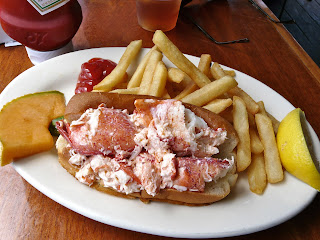
lobster roll and fries
Lobster Roll 

- Bring Bug Spray

- Use a map and bring appropriate gear if hiking in the White Mountains.

- Use Trip Advisor Forums for quick questions.  There are some really knowledgeable people on there who love to answer questions.

- See the Portland Head Lighthouse in Portland, Try a Lobster Roll, Whoopie Pie, and Maine Maple Syrup, and get into nature.


Sunday, October 28, 2012

Peaks Island Day Trip

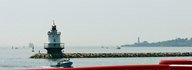
double lighthouses viewed from 20 min ferry ride to peaks
Double lighthouses viewed from 20 min ferry ride to Peaks island.

I lived in Southern Maine for 5 years before I ever took the trip out to Peaks Island.  I missed out.  It is the perfect outing for those looking for a change of scenery, casual seaside stroll, or bike ride.  This is a great idea for a fall outing since the crowds have cleared and you can expect a quiet, quaint island.
Ferry comes into Peaks Terminal

Follow this recipe for a perfect afternoon on Peaks....

10:10 am - Arrive in Portland.  Park and walk to the Ferry terminal.
10:25 am - Purchase ferry ticket.
10:40 am - Board Ferry to Peaks.
10:45 am - Ferry departs Portland.
11:05 am - Arrive at Peaks. De-board.
11:15 am - Walk up road and turn right on Island Ave.  Go to  The Peaks Island House for and early lunch and drink on the deck overlooking Casco Bay. 
12:15 pm - Exit the restaurant walk the island... This is a 4 mile stroll.
  • Continue walking down Island Ave, 
  • Turn left on New Island Ave
  • Right on Whitehead St. - You'll pass the 5th Maine Regiment Museum on your right.
  • Right on Seashore Ave which will take you down to the shore.  
  • Continue walking on Seashore Ave. You'll pass views of beach, quaint island homes, and rocky shore.
  • You will continue on Seashore Ave as it winds back into the inland island.  Continue past Pleasant Ave and wind down to Island Ave.
  • Stay on Island Ave until you return to the main part of town.  
  • Return to Ferry terminal.  
    hiker strolls along Seashore Ave
    Stroll along Seashore Ave
2:30 pm - Finish walk and grab a coffee at Peaks Cafe near the ferry terminal.
2:40 pm - Board ferry back to Portland.
2:45 pm - Depart back to Portland.


Bike Option:

- Rent a bike at Brad's Island Bicycles.  Bring cash.  This is an honor system in the off season and comes with a island map.  Once off the ferry, you can get to Brad's by walking up the road and taking a left on Island Ave.  Brad's will be about a 10 min walk on the right.  Address: 115 Island Ave., Peaks Island, ME.  Phone: (207) 766-5631

More advice for Peaks...

map around peaks
Map by google maps
- Check out the ferry schedule at http://www.cascobaylines.com/.  It usually departs Portland once an hour with some exceptions.

- The ferry is very affordable.  It is currently $7.70 round trip ($4.10 off season) with $6.50 extra if you are bringing a bicycle on.   Show up to ferry a 20 minutes prior to departure to get your ticket and get to your gate.

- There is a parking garage at the ferry terminal, but passengers shouldn't expect this to have open spots during the high season of summer.  Other options are street parking or other City of Portland garages which can be found on the Casco Bay Lines website under parking (here).  

- The ferry ride to Peaks takes 20 minutes one way and you will likely see lighthouses, islands, and lobster/fisherman hauling their catch. 

- Once on the island, you'll discover that the businesses are almost all near the ferry terminal.
biking peaks island
Biking is another option