Showing posts with label Loop. Show all posts

Saturday, August 29, 2020

Little Harbor Loop Trail - A Portsmouth Treasure

small girl on rock near water

 
In my pursuit to find all the best Seacoast hikes, I realized I had left out what many would consider the "capital" of the Seacoast - the city of Portsmouth.  I've done many trails near Portsmouth - Great Bay, Peverly Pond, and Fort Constitution , but very few nature walks actually within the city limits.  I did some research and decided to try Little Harbor Loop Hike.  I liked it so much, the next day I went back with the kids!

Here's how to recreate this adventure...

Adventure: Little Harbor Loop Trail

Getting there:  Little Harbor Loop trail has three possible parking areas along the trail.  One is at Wentworth-Coolidge Mansion located at the address: 375 Little Harbor Road in Portsmouth, New Hampshire.  This historic site and grounds is managed by New Hampshire State Parks and offers free parking and a trailhead to the loop.  The other two parking areas are located on the Creek Farm Reservation Property which is maintained by the Society for the Protection of New Hampshire Forests.

Trail sign for little harbor loop in portsmouth new hampshire
The Little Harbor Loop Trial is well signed. 
Follow the yellow blazes!
Trail:  The trailhead to Little Harbor Loop is right in the parking lot to the Wentworth-Coolidge parking lot and marked with a small wooden sign and a gap in the woods.  The important thing to note on this trail is to follow the yellow blazes.  The trail is well marked but there are several unmarked offshoots where a hiker could get off course.  Stay on the yellow trail and you’ll be fine.

The hike begins in the woods.  You will hike over uneven terrain of rocks and roots.  The trail winds through woods, crossing a driveway, passing through two rock walls, and eventually to a trail junction sign that shows you can veer off the loop to the right to visit the “view spur”.  This is definitely worth it.  Take the spur and you will be rewarded with views of the tidal bay, rocky shoreline, and a grassy marsh.  Return the way you came and continue on the yellow-blazed loop.


The trail will cross the road and enter the well signed “Creek Farm Reservation” and second parking lot.  The trail is well signed, but travels along the road - yellow blazes marked on trees on the shoulder until entering the third parking lot for this hike near the Shoals Marine Laboratory and Sagamore Creek Boat Car Top Boat Launch.


The trail continues around the grounds of the impressive building and hugs the shore, curving around an inlet marked on the map as a tidal pool. Continue to follow the yellow blazes (now marked on stones), along the shore with views of Goose Island on your right.  


The trail will cut back inland and travel the road back to the parking lot of Wentworth-Coolidge Mansion.

Little Harbor Loop trail on road
Part of the Little Harbor Loop Trail walks along the road. 
Follow the yellow blazes.
Difficulty: Mostly easy with some root/rocky footing in the first half mile.

Distance: 1.5 miles

Recommendations:

  • Little Harbor Loop Trail is managed by the New Hampshire state parks and the Society for the Protection of New Hampshire Forests.  It is open dawn to dusk.

  • A trail map is available on the Wentworth-Coolidge Mansion website.

  • Dogs are not allowed on the trail.

  • At low tide visitors can walk out to some of the close islands and tidal pool areas. Be mindful of the tide so you don’t get stuck.

  • The first half mile of the trail from Wentworth-Coolidge Mansion has a series of unmarked offshoot trails.  Stick to the yellow loop so not to impact more areas with unofficial trails- with the exception of the marked viewpoint.

I really enjoyed Little Harbor Loop twice this week. When I brought the kids, we didn't do the full loop - we just went down to the viewpoint and back.  This was the perfect length for my 2 year old.  Afterwards we enjoyed the lawn and waterfront views of the Wentworth-Coolidge Mansion who's grounds were open to the public.  I hope you get to enjoy it too!

See more photos and adventure on my INSTAGRAM and FACEBOOK!

Little Harbor Loop Trial in Portsmouth New Hampshire
Little Harbor Loop Trial in Portsmouth, New Hampshire

You might enjoy these similar experiences...

- Cutts Island Trail in Kittery

- Stonehouse Pond in Barrington

- Little River Park Loop in Lee


Monday, August 10, 2020

Morgan and Percival Loop: Ladders, Caves, and Amazing Views

Morgan Percival Loop has ladders, caves and amazing views

Somehow I'd gone this far being an avid New Hampshire hiker without even hearing about the Mount Morgan and Mount Percival peaks.  Then, thanks to social media, I've been seeing photos of people climbing ladders, pushing packs through narrow rock holes, and enjoying stunning views on these lakes region peaks.  The first chance I got, I wrangled two work friends into joining me and we thrilled at the Morgan and Percival loop hike.  

Here's how to recreate this adventure...

Adventure: Mount Morgan and Mount Percival Loop 

Getting there: These lakes region peaks are located near Squam Lake in Center Sandwich, New Hampshire.  To get there from the Seacoast, I took 101 West to 93 North.  From there, take exit 24 onto Route US-3, NH-25 toward Ashland/Holderness.  Follow US-3 for 4.5 miles, then turn left onto NH-113.  The trailhead will be on the left after 5.5 miles. There is an overflow parking lot across the street, however, be warned - this trail has been extremely popular this summer and even on a weekday morning, my friend and I got the last spot open at 10 am.  Weekday hikers should plan for 9 am or earlier and weekend possible earlier!
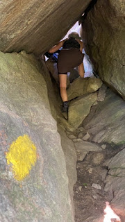
crawling through caves on mt morgan
After ladders, hikers crawl through cave on Mount Morgan
Trail: 
    Both peaks can be hit in a loop.  It was recommended to travel clockwise - hitting Mount Morgan first.  To do this, from the trailhead, hike about 0.1 mile to the junction where the trails meet.  Veer left on the Mount Morgan trail.  The trail ascends consistently through hardwood forest with moderate terrain.  The trail leads to a set of three ladders that allows you to climb a rock face.  THIS IS OPTIONAL!  My friend Kaley and her dog took the bypass while Danielle and I took the ladders.  Footwork is a little tricky on the third ladder.  Once up the ladders, the trail continues through a short and narrow cave.  Crawl through the rock and you will climb out onto a beautiful ledge with stunning views of the lakes and peaks below.  I really enjoyed this experience but those who are afraid of heights, struggle with mobility, young children, dogs, and large packs should take the bypass.  
    After the ledge, there is a short and somewhat difficult slab with high exposure to get to the near-summit view.  We spent a good half hour on this ledge view where the two trails meet up again.  From there, you will head back into the woods and pass the official summit of Mount Morgan (no view).  Continue onto the Crawford-Ridgepole trail through short, dense forest to Mount Percival.
    Mount Percival's summit has even more expansive views of lakes and peaks below.  The challenging portion of Mount Percival is directly below the summit - where hikers quickly descend into a boulder field followed by caves and rock outcrops.  At one point, we all had to remove our packs (even my small one) to descend a vertical drop into a hole.  I felt like Indiana Jones!  Looking at the map, there is a bypass for this as well, however we didn't take it.  This would be impossible for a large dog that could not be carried, a large pack (like baby carrier), or those with mobility issues.
    After the exciting caves, continue a moderate/steady descent on the Mount Percival Trail.  To get back to the parking lot, take the Morse Trail at the junction (unless you parked at the Percival parking lot), to return to your car.  
Caves and Rocks on Mount Percival
Crawling over boulders and caves on Mount Percival
Difficulty: Moderate with (optional) sections of difficulty - ladders, caves, and rock ledge/boulders

Distance: Entire loop is 5.1 miles
Enjoying the view on Mount Morgan
Enjoying the view on Mount Morgan, New Hampshire
Recommendations: 

- Take the clockwise loop with Mt Morgan first. This way you will be going with the flow of other hikers and also won't have to go down ladders.

- Parking is limited and fills fast on this popular hike.  Also, we did not have cell service in the parking lot.  Plan ahead and have a back up plan if the parking lot is full.  Street parking is prohibited. 

- There are no bathroom facilities available.

- Dogs are allowed on the trail but it is not advisable to take dogs on ladders and caves.  Take the optional bypass.  

- I do not advise carrying a baby-carrier on this hike.  The cave crawling is narrow and tight.  It would be extremely challenging and possibly unsafe to travel with a baby.

- Weather watch - ladders and caves are dangerous when wet.

- Practice LNT, practice social distancing, and wear a mask.

- Want to see what I packed for this hike? Check it out at my IGTV.


You might also enjoy these similar adventures:

Saturday, July 25, 2020

Ledges, Lichens, and a Loop - Southern Maine Nature Trail

    In the late hours when other people are scrolling social media, reading a book, or binging Netflix, I am lying in bed internet-searching for new trails for myself and my kids.  Although I hike all year round - summer is truly my biggest "hiking season".  I have summers "off" and like to fill my days with my young children hitting the trails.  Here on the Seacoast, we have amazing kid-friendly, but I'm always looking for more.  And this week, I found one!  
    Nestled in a small preserve on the South Berwick/Ogunquit town lines is a perfect little-kid loop trail that provides views of ledges and even caves - all covered with beautiful lichens and mosses.  What's more, it's a loop!

Southern Maine Nature Trail with a cave


Here's how to recreate this adventure...

Adventure: Kenyon Hills Preserve Loop Trail in South Berwick, Maine

Getting there:  For GPS purposes, the official address location is 110 Ogunquit Rd, South Berwick, Maine.  To get there from Dover, NH take Route 4 (Portland Ave) towards South Berwick, Maine.  Continue on Route 4 until it splits in South Berwick.  Curve right to get on Agamenticus Rd and drive for a quarter mile.  Turn Right on Emerys Bridge Rd and continue for 1.6 miles.  Turn right at Bennettlot Rd and continue for 4 miles.  Finally, turn right onto Ogunquit Rd.  The trailhead is on the right about 2 miles up.  The trailhead is well signed saying "Kenyon Hill Preserve: Great Works Regional Land Trust" from the road and their is a small uneven (free) parking lot.  The trail is open dawn to dusk.
kenyon hill preserve sign in South Berwick Maine
Trail sign from the road: Kenyon Hill Preserve / Great Works Regional Land Trust

Trail:
  From the parking lot, walk back from the road.  There is a small laminated signed stapled to a post showing the loop (see photo).  I also used AllTrails to record my hike so I wouldn't get lost. The trail is a well blazed one mile loop with blue blazes, however there are small small offshoot trails.  
    From the initial fork, we decided to start right - doing a counter clockwise trek.  This was a great choice because a lot of the "attractions" are early on this portion of the trail.  We saw huge glacial erratic boulders covered in lichen and moss, towering rock faces, and smaller rock piles perfect for toddler/preschoolers to climb. 
    The trail is easy but has some roots and rock tripping hazards (my four year old fell a few times).  There are small changes in elevation gain but nothing too noticeable. About half way through the loop we went up an incline and according to the AllTrails topo map, we were at the tallest point in elevation on the trail.  We scrambled up a large rock and enjoyed our lunch.   
    The last half mile of the trail was easy, flat, and straight.  Even though this trail is only one mile, our scrambling and exploring of small off-shoots clocked our hike at 1.8 miles, and we spent 90 minutes here!  The climbing rocks and cave made it a really fun one for kids, but adults will enjoy the varied views and beautiful lichen/moss covered rocks as well.
Curly lichens grown on large rock faces throughout the trail

Difficulty: The short distance and fairly easy terrain makes me categorize this trail as over all EASY but Great Works Regional Land Trust that manages it, labeled it "moderate".

Distance: 1 mile loop. However, we must have done a lot of off-trail rock exploring because I clocked our trek at 1.8 miles total.  

Recommendations:

- Parking is limited but it was not busy.  We only saw one other hiker on a sunny, summer weekday morning. There are no bathrooms or trash receptacles at the trailhead.

- The trail was clean.  Please keep it this way by carrying out your trash.

- Keep track of the blue blazes.  There are other "non-official" trails that are not blazed.  We accidentally meandered down a couple.  

- Bring bug spray.  The bugs weren't horrible but there were a few wetland type areas along the trail where the mosquitoes were noticeable.  

- Dogs are allowed on the trail.


This trail reminded me of one of our other favorite loops - the Winnie-the-Pooh Trail - that also has rock ledges and caves.  The kids really liked it and so did I.  I'm so glad my late night internet searches paid off!

Southern maine trail for kids


You might enjoy these similar adventures...


Beautiful kid friendly hike in southern maine


Monday, June 1, 2020

Peverly Pond Loop - Short and Sweet Boardwalk Loop

There are two things I absolutely love about Peverly Pond loop trail - it's short enough for my two year old to walk without being carried and it's entirely on a boardwalk.  What's more, this little 0.4 mile loop offers water views of the Great Bay National Wildlife Refuge and has a large, free parking lot.  It's perfect for a quick jaunt through the woods, quick family walk, or a stroll with the stroller.  

Peverly Pond Boardwalk

Here's how to recreate this adventure...

Adventure: Peverly Pond Loop Trail

Getting There: The trail is located at the end of Arboretum Drive in Newington, NH.  To get there from Dover area, I take 16 south to exit 3 toward route 3.  At the roundabout, go straight to get on Arboretum Drive. Take this road 2 miles until it ends at the parking lot.  The trailhead is well signed next to the restrooms.

Trail:  This flat, wide trail is a boardwalk loop.  It offers views of the pond - look for turtles and great blue herons, as well as meandering through the forest.  

Difficulty: Easy! This trail is also stroller and wheelchair friendly.

Distance: 0.4 mile loop
child walking boardwalk trail at peverly pond

Recommendations:  

- The trail can be buggy in late spring and early summer.  Pack bug spray. 
 
- No dogs allowed on this trail - leave them at home.

- Although there are public bathrooms available at the trailhead, at the time this post was written COVID 19 precautions have temporarily closed them.

- The refuge is open dawn to dusk.

You might also enjoy these similar experiences:


Views of Peverly Pond

Friday, March 6, 2020

White Ledge Loop in Winter: Moderate White Mountain Hike with a View

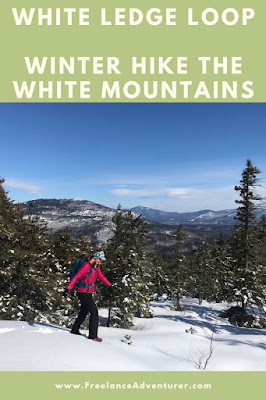
It's hard to get much better than this.  White Ledge loop trail is one of my go-to hikes.  Last weekend I finally hiked it in winter, and like every other season - it was perfect. This 4 mile hike has everything you need for a convenient and worthwhile trek: shorter drive, loop trail, moderate/dog friendly trail, and mountain views.  I've enjoyed this trail in every season.

White Ledge Loop Summit in Winter, White Mountains, NH

Here's how to recreate this adventure...

Adventure: White Ledge Trail in Winter
Trail Sign at Junction for loop.
Getting there: The trail is accessed from the White Ledge Campground on Hwy 16 in Albany, New Hampshire.  It is only 5 miles south of Conway, NH.  In winter, the campground entrance is blocked and not plowed.  We parked on the side of the highway, not ideal, but there aren't many options.  We saw another hiker park in the business lot across the highway, then walk across but I'm not sure if that's technically "allowed".  I love that this trail is only one hour from my home in Rochester. In camp-season months, hikers park just inside the campground entrance on the right and there is a WMNF fee associated with parking (currently $5). 

Trail: Walk straight through the campground entrance to the clearly marked trailhead sign at the back of the campground.

The trail starts straight and flat. There is a small stream crossing in the first quarter mile.  Follow the yellow blazes for 0.3 miles until you reach the trail junction and start of the loop.  I have only ever gone counterclockwise.  This choice will lead to a longer and more gradual incline and your descent steep and shorter. 

The first third of the hike is a gradual incline through hardwood forest with the shadow of White Ledge summit on your left.  Be careful to stay on the trail.  In winter, we discovered it was easy to lose your way as there were no fresh tracks or path to follow.  The trail will take a left turn and start to increase steepness as you climb up the ledge.  In winter, footing with traction was easy as all the rocks and slab were covered in snow.  Around 2 miles, the blazes turned to cairns and for a couple minutes we had trouble finding the buried rocks.  Eventually we found the trail and continued up to the ledges.  As you climb, look behind you!  We were gifted with gorgeous clear views! 

At about 2.5 miles, you will reach the official summit - a partially clear view on your left of southern Whites.  Past the peak, you continue on the loop and get some excellent views of Mt Chocorua on your right.  There are a few steep parts on the early descent but nothing I'd label as difficult by White Mountain standards.  MicroSpikes and trekking poles helped keep our footing.

Winter proved to be another great season to hike White Ledge loop trail.  As usual, even on a gorgeous weekend, we only saw one other hiking pair here.  This is the perfect hike for someone looking for a sweet solitude hike with some great views.
Keep an eye out for Blazes.  It's easy to lose the trail.
Difficulty: Moderate

Distance: 4.1 mile loop plus extra walking through the campground to road.
Winter afternoon light.  Can you see the trail?  Look for blazes!
Recommendations: 

- Trail can be icy or snowy in winter.  I recommend preparing with traction.  I personally prefer using MicroSpikes and trekking poles to keep my footing but saw the other hikers with snowshoes. 

- If hiking in winter, you'll have to park on the side of the highway.  There is no access to bathrooms and no parking fee required. The campground is open late May - labor day weekend.  During these months, park inside the gate and expect to pay at the self service area.

- Dogs are allowed on the trail. 

- Careful to stay on the trail.  The yellow blazes are easy to lose and the trail is not well worn.  Use an AMC White Mountains Trail Map #3 to find location and trail information.

View of Mount Chocorua from White Ledge Loop Trail.
You might also enjoy these similar experiences:

- South Moat Mountain in Winter

- Boulder Loop Trail

- Liebeskinds Loop in Winter

Tuesday, June 28, 2016

White Ledge Trail - Solitude and Views near North Conway

Views from White Ledge Trail
My quest continues to try new hikes in the Whites.  Now that I'm carrying a baby as well as a pack, I need to be a little more strategic about where I hike.  Since carrying a baby on your front limits visibility and stability, I've been picking out trails that have relatively easy footwork but still have amazing views.  So far I've taken baby Lucien up Mt. Major, Mt. Willard, and Mt. Kerasarge North (as well as multiple shorter nature walks).  All these peaks had great views and I was able to tackle it easily with the added weight and constraints of a newborn on my chest and a backpack on my back.

Slab portion near summit of White Ledge
Scouring my AMC White Mountain maps, I stumbled upon a 4.1 mile loop hike just off Highway 16 south of Conway.  After reading the trail description, I decided it was worth a try.  White Ledge Trail did not disappoint!  It was a great hike- a good combination of flat, hills, and slab hiking.  The views of the lower White Mountain range and neighboring lakes was stunning.  What's also surprising was that for such a family-friendly hike, on a nice summer day, we only ran into one other hiker.  Gretchen (a local from Albany) informed us that the hike is never crowded- a gem in the Whites!  It was a great way to spend the day with my son and mom.

Here's how to recreate this adventure...


Adventure: White Ledge Trail Loop

Getting there: White Ledge Trail is located in the White Ledge Campground off Highway 16
Trail sign at back of campground. Park at front where marked.
in Albany which is about 15-20 minutes south of North Conway.  Unfortunately, the campground sign had been removed or broken when we came (June 2016), but fortunately I had a map.  Coming from the south, the campground is past the Piper Trail on the left.  Once in the campground, pass the campground pay station (apparently day use does not need to pay) and park on the right where it says 'Day use and Picnic Parking'.  There is an outhouse and picnic area.  To access the trail, walk up the campground loop.  The trail is located 'in the back' of the campground before the the road loops around.  There will be a sign marking the trail.


Mom enjoys White Ledge Views.
Trail:  The trail begins by walking through some hardwood forest.  The trail here is easy with a small stream crossing.  Follow the yellow blazes for 0.3 miles until you reach the trail junction for the loop.  We decided to take a right and do the trail counter clockwise.  If you go this way, you will reach the best views at the last mile of the hike.  The loop part itself is 3.5 miles.  The first part was relatively flat.  There was a little elevation gain here and there and then the trail would level out.  I could tell it was not frequently traveled as a few times, I grew concerned we had lost the trail.  Be careful and watch for the blazes!  Around 2 miles, the trail increases elevation and includes some slabby climbing.  Blazes turn to carens as you get out of the trees and onto rock.  Nice views start to appear behind you and various ledge poke out with glimpses of the surrounding forest and mountains.

Around 2.5 miles (traveling counter clockwise) you will reach the summit.  Someone has spray
Spur Trail on the way down has gorgeous view!
painted "VIEW" onto the trail with an arrow so it's tricky to miss.  We enjoyed our lunch on the summit before taking the the rest of the loop down.  Our one hiker encounter, Gretchen, gave a tip that past the summit about 15 minutes, a spur trail on the left will take you to a great view of the glacier-scraped lakes below.  It was a great tip and a beautiful view.  We returned to the fork and then hiked out the 0.3 miles to the campground.  It was a beautiful easy-moderate hike.  It would be great with families or just someone seeking solitude and an awesome view.  I can't wait to go back!


Difficulty:  Easy-Moderate.  There is no difficult footwork (by White Mountain standards), but the mileage makes this a moderate hike since it takes 3-4 hours.

Recommendations:

- Use your AMC White Mountains Trail Map 3 to find the location of the hike.  When we visited
(June 2016), the White Ledge Campground Sign had been removed off Rt. 16.

- Although the hike is relatively easy, weather and conditions can change rapidly in the White Mountains.  Bring plenty of water (at least 1 L a person), snacks, map, rain gear, and a first aid kit.

- Watch carefully for the Yellow Blazes.  The trial is not very worn and it's easy to mistake a deer trail or spur trail for the actual trail.  At one point, my mom and I retraced our steps backwards to make sure we were still on the trail.

- There are pit toilets available at the trailhead.  From what I could tell, it did not cost anything to park as a day visitor.

My mom, baby Lucien, and I really enjoyed this quiet and enjoyable hike.  It was a treat to find solitude in the woods and experience a new view.
Lucien and I enjoy the view

You might also enjoy these hikes...

- Mt. Major is a Major Treat!

- Liebskinds Loop in Pinkham Notch

- Welch Dickey Loop

Selfie on Summit of White Ledge

Saturday, November 7, 2015

Welch-Dickey Loop - Amazing Views in the Heart of the White Mountains

View of Mt. Welch from Mt. Dickey on Welch-Dickey loop
I've been wanting to do this hike for a long time.  I mean - this is one of the most popular hikes in the White Mountains - and I'd never tried it!  So when my friend Sarah suggested we take the dogs for a late fall hike on the Welch-Dickey loop, I jumped at the chance.  It is easy to see why this trail is so popular - the 4.5 mile hike is a true loop that includes amazing mountain views without the need to go to 4,000 ft (the peaks are in the mid - 2000ft).  Late fall was a great time because the crowds were low and the weather still mild enough that we didn't need traction on our boots.  Here's how to recreate this adventure...

Adventure:  Welch-Dickey Mountain Loop
Leaf-covered trail in November

Getting there:  The trailhead is located off I-93 near the town of Waterville Valley.  To get there, I took I-93 North to exit 28.  Drive East on Rt 49 toward Waterville Valley.  Turn left onto Mad River Road then turn right onto Upper Mad River Road.  Follow the "hiking" sign and turn left onto Orris Road.  The parking lot with be on the right with a well marked sign.

Trail:  The trailhead is at the end of the parking lot.  This is a true loop.  Just walk 0.1 mile down the trail and you'll come to the fork.  We decided to do a counter-clockwise loop by taking the right fork first.  This appeared to be the more popular direction, but hikers could enjoy either way with equal challenge-level.
     We followed the yellow blazes up a gradual and moderate climb.  Soon we popped-out onto a ledge and viewpoint.  I could see the Sandwich Range to the south and behind us, the summits of Welch and Dickey. We continued up granite slab, all-the-while enjoying the views.  We were lucky to hike the trail on a dry day, but I imagine this trail could be very dangerous if it was wet or icy.  From the summit of Mt. Dickey, we descended down a slab ridge.  This is your last time above the trees.  We enjoyed a snack and staring at the loop hike that we had almost completed.  Continue down the trail and in no time at all, you'll be back at the parking lot.
      The dogs handled this trail with no problems at all and we came across many other dogs on the trail.

Be prepared to walk up slab near the summit of both peaks.
Difficulty:  Moderate-  This trail starts out easy and turns to a moderate slab climb near the summits.  That said, if it's wet or icy, this trail could quickly become dangerous above treeline.  The granite slab is great for open views, but hikers should be careful when climbing.

Enjoying the view of Mt. Dickey from Mt. Welch
Distance: 4.5 mile loop

Recommendations:

- Get there early!  Even in November, the parking lot and trail is very popular. At 9 am the parking lot was mostly full.

- You will need a National Park/Forest parking pass or $3 per vehicle to park in the lot. Bring exact cash or check.  There are envelopes to deposit your money in near the trailhead sign.

- There are pit toilets at the parking lot.

- There is no cell service in the lot.  Plan accordingly.
Final ridge walk down from Mt. Dickey

- Remember that the Whites have their own weather.  It might be 70 and sunny in Boston, but icy trail conditions up north.  For late fall hikes, bring microspikes or other traction options just in case.  A warm coat, gloves, and hat are a must.

I loved this moderate loop.  It would be wonderful to try it in every season.  I can see why it's a favorite for hikers in the area.

You Might Enjoy These Hikes As Well...

5 Best Family Hikes in the White Mountains

Lonesome Lake - Perfect Family Hike

5 Best Fall Foliage Hikes in the White Mountains

Summit gets some love!

Please leave comments and questions below.