 |
| Boot Spur to Tuckerman Ravine Trail |
Here's how to recreate this adventure...
Adventure: Mt.Washington summit loop via Tuckermas, Boot Spur, Davis, Tuckermans, Nelson Craig, Alpine Garden, and Lion's Head.
Getting there: Our adventure began at AMC Pinkham Notch Visitor Center. To get there, take Route 16 north out of North Conway. At the 302/16 intersection, turn right to stay on Route 16. About 11 miles from the intersection you will reach the visitor center on the left. There is a large parking lot, AMC visitor center/dining hall and Joe Dodge Lodge. The Tuckerman Ravine trailhead is located directly behind the main visitor center building with a well marked sign and is the starting point for many of the other trails that come off it.
 |
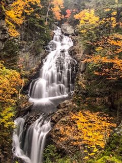
| Crystal Cascade on the Tuckerman Ravine Trail near Pinkham Notch Visitor Center. |
Trail: This hike involved many trails. There are numerous stories of people who have gotten lost in this region. It is important to use a AMC trail map (available for purchase in the visitor center) and familiarize yourself with it before departure. Below is the way we took...
Part 1: Visitor Center to Hermit Lake Shelter
We started by taking the Tuckerman Ravine trail from Pinkham Notch. This trail is wide, a steady uphill, and uneven terrain. My mom once asked "Is this a dried up river bed?" and that statement perfectly describes the trail. Along the way, enjoy views of Crystal Cascade - a photogenic waterfall. This section is 2.4 miles one way and ends at a shelter deep in Tuckerman's Ravine.
Part 2: Hermit Lake to Boot Spur
From Hermit Lake Shelter, we took the Boot Spur Link...up. I've taken this trail with Matt a few years ago, and we took it down. It's one of the steepest trails I've ever done in the White Mountains and not for the weak knees. When you get to the ridge, the link meets up with Boot Spur Trail. Continue up the Boot Spur trail until you at the Davis Path intersection. This section is 1.3 miles.
Part 3: Davis Path to Tuckerman Junction
From Boot Spur, take the Davis Path toward the summit. This exposed rocky trail is marked with cairns. Turn right at the Lawn Cutoff and continue towards the summit. Clear days provide stunning views of Mt. Washington's summit and surround ridges. The Lawn Cutoff ends at Tuckerman Junction where five points of trail meet. This section is 1.0 mile.
Part 4: From Tuckerman Junction, take Tuckerman Ravine Trail the last half mile to the summit. This steep climb is covered in boulders and extremely exposed and steep. Emerging at this peak can be somewhat anticlimactic since the Auto Road and Cog railway brings non-hiking tourists to the summit it can be crowded and busy. This section is 1.0 mile.
 |
| View of the Mount Washington summit from the top of Boot Spur |
After a warm beverage and bathroom break in the summit's visitor center, we headed back down a different way.
Part 5: Nelson Craig Trail to Alpine Garden
From the summit, we took the Nelson Craig Trail which parallel's the Auto Road. At the Huntington Ravine Trail, we turned right for a short distance until it met with the Alpine Garden Trail. Huntington Ravine Trail is dangerous and never recommended for decent. We decided to take the Alpine Garden trail which cuts back along the ravine and reconnects with Lion's Head trail and Tuckerman Ravine Trail. This section is 1.9 mile.
Part 6: Lion Head Trail to Tuckerman Ravine Trail
After 0.9 miles of the Alpine Garden Trail, it reaches Lion's Head Trail. From here we took the steep and sometimes technical Lion Head Trail down the mountain. At 1.1 miles, it reconnects with Tuckerman Ravine trail just below Hermit Lake.
Part 7: Tuckerman Ravine Trail to Pinkham Notch Visitor Center
We finished the hike by retracing steps down the river-bed-like Tuckerman trail back to the Pinkham Notch Visitor Center. This is about 2 miles. Done!
 |
| Photo of Map. All hikers should have a purchased AMC map. |
Distance: 10.7 miles using this path.
 |
| Fall Foliage at its best on the Tuckerman Ravine Trail |
Recommendations:
- Each year there are tragic stories of injury and even death on Mt. Washington. This peak boasts the most extreme weather in the world and hikers often underestimate the challenge because its relatively low elevation. Plan ahead and be prepared. Matt and I each packed multiple layers including base layers, rain layers, and multiple poly blend warm layers - plus warm hats, gloves, and scarves. We carried 2 L of water a person, food, and a large first aid kit. We also carry the AMC map. Be prepared to scrap your plans based on weather.
- Parking is available at Pinkham Notch visitor center but is very popular and crowded in summer. Plan ahead by getting there early.
Although Mount Washington wouldn't have been my choice of hike that day, I cannot imagine a better day to summit. We were lucky with weather, visibility, and trail conditions. Less than 48 hours later - the entire peak was covered in ice and snow. Be safe out there!
 |
| Views from Alpine Garden Trail |
You might also enjoy...
- Mt Osceola via Tripoli Road
- Mt Carrigan Loop
- One Night on Mt Liberty


