Showing posts with label Lakes Region. Show all posts

Monday, August 10, 2020

Morgan and Percival Loop: Ladders, Caves, and Amazing Views

Morgan Percival Loop has ladders, caves and amazing views

Somehow I'd gone this far being an avid New Hampshire hiker without even hearing about the Mount Morgan and Mount Percival peaks.  Then, thanks to social media, I've been seeing photos of people climbing ladders, pushing packs through narrow rock holes, and enjoying stunning views on these lakes region peaks.  The first chance I got, I wrangled two work friends into joining me and we thrilled at the Morgan and Percival loop hike.  

Here's how to recreate this adventure...

Adventure: Mount Morgan and Mount Percival Loop 

Getting there: These lakes region peaks are located near Squam Lake in Center Sandwich, New Hampshire.  To get there from the Seacoast, I took 101 West to 93 North.  From there, take exit 24 onto Route US-3, NH-25 toward Ashland/Holderness.  Follow US-3 for 4.5 miles, then turn left onto NH-113.  The trailhead will be on the left after 5.5 miles. There is an overflow parking lot across the street, however, be warned - this trail has been extremely popular this summer and even on a weekday morning, my friend and I got the last spot open at 10 am.  Weekday hikers should plan for 9 am or earlier and weekend possible earlier!
crawling through caves on mt morgan
After ladders, hikers crawl through cave on Mount Morgan
Trail: 
    Both peaks can be hit in a loop.  It was recommended to travel clockwise - hitting Mount Morgan first.  To do this, from the trailhead, hike about 0.1 mile to the junction where the trails meet.  Veer left on the Mount Morgan trail.  The trail ascends consistently through hardwood forest with moderate terrain.  The trail leads to a set of three ladders that allows you to climb a rock face.  THIS IS OPTIONAL!  My friend Kaley and her dog took the bypass while Danielle and I took the ladders.  Footwork is a little tricky on the third ladder.  Once up the ladders, the trail continues through a short and narrow cave.  Crawl through the rock and you will climb out onto a beautiful ledge with stunning views of the lakes and peaks below.  I really enjoyed this experience but those who are afraid of heights, struggle with mobility, young children, dogs, and large packs should take the bypass.  
    After the ledge, there is a short and somewhat difficult slab with high exposure to get to the near-summit view.  We spent a good half hour on this ledge view where the two trails meet up again.  From there, you will head back into the woods and pass the official summit of Mount Morgan (no view).  Continue onto the Crawford-Ridgepole trail through short, dense forest to Mount Percival.
    Mount Percival's summit has even more expansive views of lakes and peaks below.  The challenging portion of Mount Percival is directly below the summit - where hikers quickly descend into a boulder field followed by caves and rock outcrops.  At one point, we all had to remove our packs (even my small one) to descend a vertical drop into a hole.  I felt like Indiana Jones!  Looking at the map, there is a bypass for this as well, however we didn't take it.  This would be impossible for a large dog that could not be carried, a large pack (like baby carrier), or those with mobility issues.
    After the exciting caves, continue a moderate/steady descent on the Mount Percival Trail.  To get back to the parking lot, take the Morse Trail at the junction (unless you parked at the Percival parking lot), to return to your car.  
Caves and Rocks on Mount Percival
Crawling over boulders and caves on Mount Percival
Difficulty: Moderate with (optional) sections of difficulty - ladders, caves, and rock ledge/boulders

Distance: Entire loop is 5.1 miles
Enjoying the view on Mount Morgan
Enjoying the view on Mount Morgan, New Hampshire
Recommendations: 

- Take the clockwise loop with Mt Morgan first. This way you will be going with the flow of other hikers and also won't have to go down ladders.

- Parking is limited and fills fast on this popular hike.  Also, we did not have cell service in the parking lot.  Plan ahead and have a back up plan if the parking lot is full.  Street parking is prohibited. 

- There are no bathroom facilities available.

- Dogs are allowed on the trail but it is not advisable to take dogs on ladders and caves.  Take the optional bypass.  

- I do not advise carrying a baby-carrier on this hike.  The cave crawling is narrow and tight.  It would be extremely challenging and possibly unsafe to travel with a baby.

- Weather watch - ladders and caves are dangerous when wet.

- Practice LNT, practice social distancing, and wear a mask.

- Want to see what I packed for this hike? Check it out at my IGTV.


You might also enjoy these similar adventures:

Wednesday, July 22, 2020

5 Miles, 3 Peaks, 1 Loop: Day Hike in New Hampshire's Lakes Region

New Hampshire Lake region hike

My summer quest to seek out new and beautiful hikes continues!  I "found" this hike by following another New Hampshire hiker on Instagram.  She showed photos of a loop hike that incorporated three mountain peaks - all with fantastic views of New Hampshire's iconic Lakes Region.  This is hike was an attractive choice for me for three reasons:

1. It's close(r) than the Whites (only an hour from the Seacoast)
2. It has amazing views of mountains and lakes from the peaks
3. It's a loop!!!

I found friends to tackle it with me on a hot and humid late June day.   I loved it so much...I did it again the next week!!

Here's how to recreate this adventure...

Adventure: Piper, Belknap, and Gunstock Loop

Getting there: The trailhead is located on Carriage Road in Gilford, New Hampshire.  To get there from the Seacoast, I drove west on Route 11 (Mt Major Hwy) from Alton toward Gilford.  From here, take a left onto 11A (Cherry Valley Road).  Drive about 8 miles and take a left onto Belknap Mountain Road.  After 1.3 miles, turn left onto Carriage Road.  After 0.4 miles the lower parking lot is on the left.  It has room for about 4 cars.  Parking is not permitted along the road.  When we got there the lot was full (weekday morning) but there is an overflow lot about a quarter mile (guessing) up the road on the right that can hold an additional 5 cars or so.  This is where we parked then walked down the road to the trailhead.
Standing on Piper Mountain
Standing on Summit of Piper Mountain
Trail:  The trail system is complex but well signed.  I recommend using a map or recording your trip through AllTrails.  We frequently double checked were on the right trail system.  I decided to take the trail clockwise- starting with Gunstock, then Belknap, then Piper.  
    The trail entrance to Gunstock Mountain is just at the lower parking lot.  It was actually kind of hard to find but it's just up hill from the large trailhead sign.  
    Once on the trail it was a pretty steady up to the Gunstock summit.  Before you reach the actual peak there's a nice viewpoint (with a picnic table) that overlooks the lakes.  At the summit you are reminded that this is a ski hill!  We saw another hiking group eating a snack in the shade of the chair lift.  There are fabulous views of Lake Winnipesaukee. 
    From Gunstock, go back into the woods and follow signs to Belknap.  The trail dips down gradually and then climbs again to get to Belknap Mountain - peaked with a climbable fire tower for the view!
To get to Piper Mountain, take the White Trail to the Old Piper Trail to Piper Mountain Summit.  This is a fairly bare summit and my favorite of the three.  I enjoyed wandering around to see views from all sides. 
Continue on the Old Piper Trail down to the parking lot.  
  
Difficulty: Moderate - The up and down make this a workout.  All Trails claims there is 1,827 ft of elevation gain in total which is nothing to squawk at!  Still, there is no technical skill needed for the climb (no slab or scrambling) - just good old fashioned up and down.  

sign on gunstock mountain trail

Distance: 5.5 mile loop

Recommendations: 

- I've done this hike twice in the last month.  The first time, I arrived on a sunny weekday around 10 am and the lower lot was full (4-5 cars).  There were still plenty of spaces in the upper lot (4-5 cars).  The street is covered with "No Parking" signs for over a mile, so if you want to guarantee a spot, get there early and avoid weekends.  The second time I went it was a cloudy/rainy day and there was no competition for spots.

- Use AllTrails to help guide your way.  There are a lot of side trails running in and out of Gunstock and Piper and a hiker could easily take the wrong trail.  All the trails are well marked, but unless you have a clear idea of which to take, I'd recommend the assistance of a map or technology.

- There are no bathroom facilities at the trailhead.

- This is a dog friendly trail.

My friends and I really enjoyed this loop.  If felt like we got so much bang for our buck!  I ended up going back the next week and did just the Piper peak in the rain with another friend.  What a difference the rain made - gorgeous bright green moss and trickling streams really gave the trail a romantic vibe.  This hike is one of my new favorites!
Views in Belknap Mountain Range

You might also enjoy these adventures...


Monday, September 2, 2013

Mt. Major is a Major Treat!

Brothers summit Mt. Major on their first mountain hike.

What better way to wrap up the summer than with a hike?  On this occasion, my friend Ingrid and I decided to hike Mt. Major - a tiny mountain (1750 ft) on the shores of the mighty Lake Winnipesaukee.  It was exciting having her nephews along.  The 5th grader and 8th grader had never hiked before and afterwards said that this adventure was the highlight of their summer!  The short mountain hike offered breathtaking views, varied terrain, and amphibious critters in the leaves.
Orange Trail begins as a gradual walk in the woods.

This is an perfect hike for first time hikers, families, and those looking for a short hike on a beautiful day.

Here is how you can recreate this adventure... 

Adventure:  Mt. Major hike in Alton, NH

Getting there:  I took Rt 16 North to the Alton exit.  Follow Rt. 11 West towards Alton.  The trailhead is a few miles past the village of Alton Bay.  The trailhead is a clearly marked parking lot on the left.  There is no parking fee and there are no bathrooms at the trailhead.
Climbing over and through
glacial erratics on Boulder Trail.

Trail:  There are two main trails to the summit from this trailhead.  We took the Boulder Loop Trail up and the Mt. Major Trail trail down.  This made a pleasant loop.  The Boulder Loop Trail (Orange Blaze) is slightly less traveled and the large boulders make it a better choice to navigate on the uphill.  This is accessed on the left side at the end of the parking lot.  
From the summit, we took the Mt. Major Trail (Blue Blaze) down.  At first there are some steep/slabby portions that would be very challenging if wet, but it gradually became easier as we descended.  Both trails travel through hardwood forest.  The boys enjoyed finding Eastern Newts and native frogs in the leaves and under rocks.  Evidence of large glacial erratic boulders dot the landscape and at some points provide a challenge on the trails.  Another point of interest was the rock shelter at the summit.  This was fun for kids to climb, and I imagine provides a relief to wind on blustery days.  
Both young and old enjoyed the trek up Mt. Major.  I'd love to do it again in the fall when the leaves are all changed!


Approaching the summit on the
Boulder Trail.
Difficulty:  This was an easy to moderate mountain hike.  Boulders and slab near the summit provided some challenges.  Those with poor knees should consider using trekking poles on the downhill.  It is a great hike for children because it provides unique and varied terrain with an awesome view.  Our 14 month old, 5th grader, and 8th grader all enjoyed it.  (The 14 month old was carried up.  :-) )  For more family friend hikes click "Family" on the Labels on the right.  

Distance:  The loop is about 3.9 miles round trip.  We did the hike in 2.5 hours which included a long lunch break at the summit.  

Recommendations:  
-  We (perhaps stupidly) visited this hike on Labor Day weekend.  When I arrived at the 50 spot (or more) parking lot at 10 am, all spots were already full.  By the time we left at 1:30 pm, parked cars lined the side of Rt 11 for a quarter mile.  This is a POPULAR hiking spot in summer and especially on holidays.  I recommend getting to the parking lot early and taking the less traveled Boulder Trail up to avoid crowds. Still, there was plenty of room for all.  As you can see in my photo below, don't expect a serene and peaceful summit.  Children, adults, and dogs socialized, ate, and played at the top of the mountain.  If you want a more peaceful experience, visit on a weekday and avoid the summer.  
Not-so-peaceful summit on summer holiday weekend.

- Bring at least 1 Liter of water per person, snacks, and appropriate hiking gear.  Even though it's a fairly short hike (3.9 miles), it's 1150 ft in elevation gain is enough to get your heart beating.  Take breaks and bring a windbreaker for the summit.  

The four of us really enjoyed this hike up Mt. Major.  From the summit we could see the tiny boats below zip through Lake Winnipesaukee and the tall White Mountains in the distance.  It was a joy hiking with two middle school boys on their first mountain climb.  They loved the experience.  This is the perfect family hike for first timers.  Enjoy!

The boys found newts and frogs!

Ingrid and I enjoy another hike together.


Please leave comments and questions below...

Sunday, October 21, 2012

Fabulous Fall Foliage Family Friendly Hikes!


Fall in New England
Fall in New England


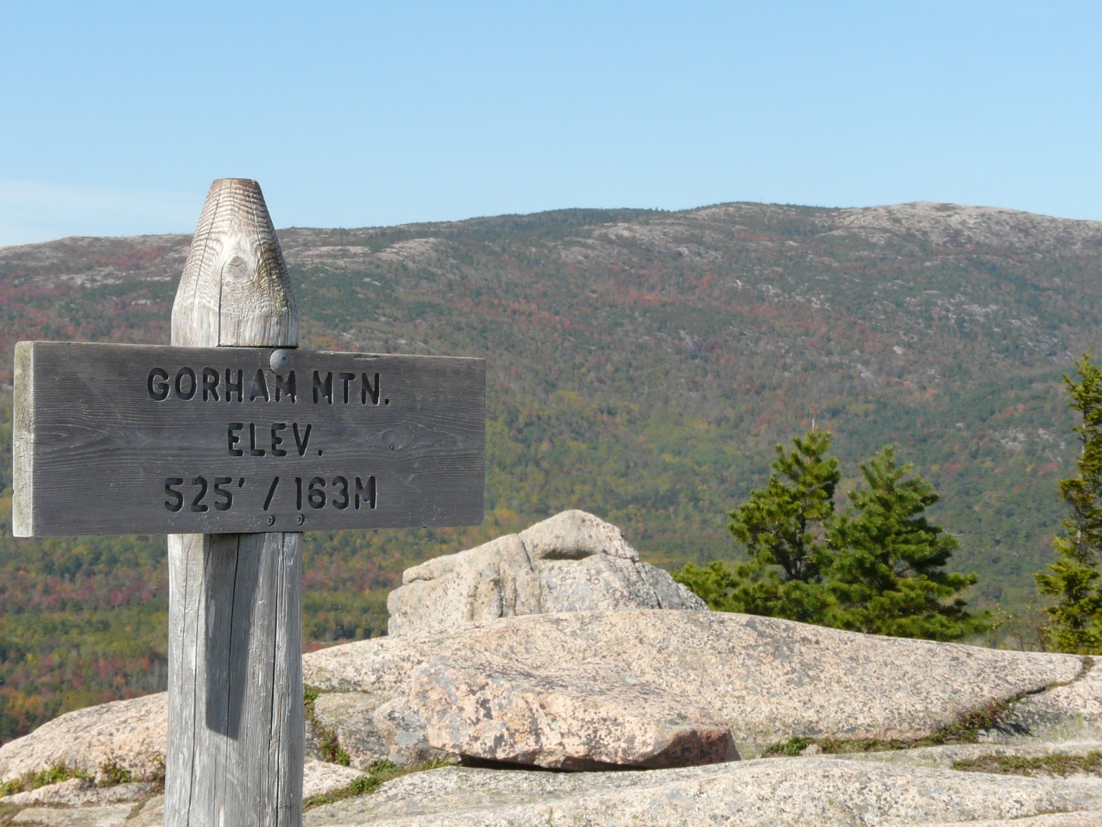
Gorham Mountain Acadia National Park
Gorham Mountain, Acadia National Park
Leaf Peeper? Here are a few great fall hikes.  Remember fall weather can be unpredictable.  Bring warm layers and rain gear, water and snacks, and a reliable map.


Gorham Mountain Summit Sign
Gorham Mtn, Acadia
1.  Gorham Mountain,
Acadia National Park, Maine  
- Acadia's trees are mostly hardwoods which makes it a wonderful place to experience the changing of seasons.  There is a plethera of family friendly hikes including a stroll around Jordan Pond Nature Trail, Bubble Rock Trail, and Cadillac Mountain.  The one I recommend here for some great foliage views is the Gorham Mountain Trail.  This is a moderately strenuous hike with some steep grades but accessible to most fit people.  Too access, park in the Gorham Mountain Parking area past Thunder Hole.  The hike is 1.8 miles round trip.  It provides many stunning views.

Summit of Mt. Willard2.  Mt. Willard, 
Crawford Notch State Park, New Hampshire 
- Don't let the term "Mountain" scare you.  You will get a great bang (in views) for your buck on this hike.  Located in Crawford Notch State Park, NH, this 3.2 mile round trip hike takes you up 900 feet to a gorgeous view point looking down into the U-shaped valley.  Park at the AMC Highland Center at Crawford Notch.  Bring a snack to share at the summit.  You'll want to drink it in.


View from summit of Mt. Willard
View from Mt. Willard Summit


3.  Cardigan Mountain,
Cardigan Mountain State Park, New Hampshire
- There are multiple access points and trails to the summit of Mt. Cardigan in the New Hampshire Lakes region.  The summit of this mountain is completely bare due to a fire back in the day so you will experience amazing 360 views when you reach the still operational fire tower at the summit.  The nearby Mount Firescrew is worth a trip too if you want to elongate your loop.  The shortest/easiest hike is up the West Ridge Trail which can be accessed from AMC Cardigan Lodge.  The hike up Cardigan is 2.6 miles one way.  Plan to spend the whole day hiking and pack accordingly.  AMC Cardigan Lodge provides comfy lodging and food as well as a camp ground for the overnight trip.
hiking cardigan in new hampshire
Hiking near Cardigan Mountain
I welcome comments and suggestions of other awesome fall hikes!  Let me know!