Monday, June 22, 2020

Bald Peak - Mountain View at less than 3,000 feet

Last week, after visiting Sugar Hill to see the lupines, my friend Kaley and I decided to tackle a hike in the area before heading back to the Seacoast.  Bald Peak came up in my All Trails search as being in the area, having a view, and being a moderate climb.  The 4.5 mile out-and-back trail was lightly trafficked on a June Tuesday afternoon and all I hoped for - moderate climb and amazing summit views all to ourselves.  

Enjoying a view with dog on Bald Peak, White Mountains


Here's how to recreate this adventure...

Adventure: Mt. Kinsman Trail to Bald Peak

Getting there: The Mt. Kinsman trailhead is located just north of Franconia Notch State park in Franconia, NH.  To get there from the Seacoast or Massachusetts, take I-93 North through Franconia Notch.  Take exit 34 C onto NH-18  North toward Echo Lake.  Follow NH-18 north 6 miles and turn left onto Kerr Rd which turns into Wells Rd. After 2 miles, turn left onto NH-116 South.  The trailhead is 2 miles down this road on the left. There is a small parking lot.  There is no fee box or bathrooms.  It is two hours from my home in Rochester/Dover area.

Waterfall on Mt Kinsman Trail
Waterfall along Mt Kinsman Trail

Trail: 
The trail is mostly a steady uphill climb.  Although strenuous to constantly climb up, there is no technical slab, rocks, or slides on this hike.  We slowly climbed through hardwood forest, passing what I assume is some sort of maple shack in the first quarter mile.  The last mile or so we were rewarded with some small stream crossings including some beautiful cascades and a small waterfall.  Water was low and it was easy to cross.  
    The last quarter mile we reached the junction for the Bald Peak spur.  Turn right and follow the spur trail that brings you to the open peak.  The "summit" rewards you with a gorgeous 270 degree view of the Kinsmans and northern Franconia Notch.  There's a large open rock slab with a boulder sitting in the middle. We loved sitting in the sun and enjoying the view.  Kaley even said she thinks it's more impressive than Mt Willard (I disagree).  To return to the car, go back the same way you came up.  It is an out-and-back trail.

Difficulty: Moderate.  The steady uphill climb can make you really huff and puff and small brook crossings can be somewhat challenging but there's no technical hiking/climbing skills needed.

Bald Peak Spur Trail
Distance: 4.5 miles total 

Recommendations: 

- There are no bathroom facilities available at the trail head. 

- Parking is free.

- Hike this in June and pair it with a trip to see the Sugar Hill lupines!

- This is a dog friendly hike.  Please be considerate to hikers and leash your dog when approaching others.


Panorama of summit of bald peak
Panorama of summit of Bald Peak

A Perfect Day

Combine wildflower viewing with a White Mountain hike and stellar views made for a perfect day in the Whites.  Perhaps I will have to recreate this next June!

You might also enjoy these similar adventures...


View of Mount Kinsman from Bald Peak in the White Mountains
View of Mount Kinsman from Bald Peak

Thursday, June 18, 2020

Sugar Hill Lupines - Wildflower Photo Spots


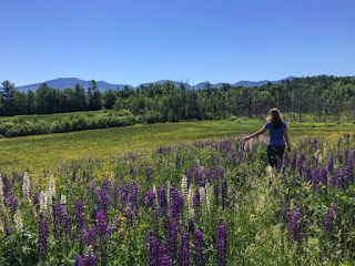
I've been wanting to go to Sugar Hill, New Hampshire for years to see the yearly lupine blooms.  Unfortunately, something has always stopped me from making the drive during it's short season.  Usually, as a teacher June would be my craziest and most hectic month of work.  That, coupled with the two hour drive each way from my home on the Seacoast, and also a photo trip not being the best choice for toddlers kept me away.  Also, the town celebrates the blooms with a yearly lupine festival and although this sounds wonderful to many, I'm not one for crowds and stressful parking situations.  However... this year due to COVID, the festival has been canceled, summer break started early, and the kids are still in daycare part time.  For the first time in YEARS, I realized I could go!  Perhaps it's a perfect time for you to go too? It's not too late!

Here's how to recreate this adventure...

Adventure: Walking through fields of lupines in Sugar Hill, New Hampshire

Getting there: The small town of Sugar Hill is located on the northwestern outskirts of the White Mountain National Forest. From Seacoast New Hampshire, take I-93 North.  Take exit 38 toward NH-18/NH-116/NH-117/NH-142 toward Franconia/Sugar Hill.  Take NH-117 toward Sugar Hill.  See below for my photo spots!

When To Go: Peak lupine season in Sugar Hill is the second week in June.  I went June 16, 2020 and it was peak!  Now it is June 18 and told still peak.

Photo Spots:  I made three photo stops on my photo tour but you could easily have more.  Here they are below:

Photo Stop 1:  Polly's Pancake Parlor. 
Polly's Pancake Parlor is located at 672 Sugar Hill Road and was the first stop on my photo tour.  Due to COVID, the adorable breakfast restaurant was closed which left a wide open parking lot for my first stop.  Across from the diner is a large field with a moderate patch (I'd guess half acre) of closely growing lupines.  Views of the mountains are a beautiful backdrop, as is the old barn with a white horse casually munching.  Previous visitors have made trails through the flowers.  It was gorgeous!

Walking through lupines across from Polly's Pancake Parlor in Sugar Hill, NH.
Barn across from Polly's Pankcake Parlor.
Barn across from Polly's Pancake Parlor.

Photo Stop 2: Sugar Hill Road and the Stone Wall.  
From Polly's, continue up Sugar Hill Road and there will be another field on your right.  Multiple cars were pulled over for this spot.  A stone wall along the road opened to a path to enter.  This spot is more packed with flowers and tight trails wove through the blooms.  In the back of the field are some large bounders which make a great photo spot or way to climb up and view the flowers.  There are no mountain views here but the flowers were the prettiest I saw. 

Dense lupines on Sugar Hill Road.

Enjoying sitting on a rock surrounded by lupines
Enjoying sitting on a rock surrounded by lupines.

Photo Stop 3: St Matthew's Chapel
From Photo Stop 2, continue up Sugar Hill Road about a mile to where it curves and you will see St. Matthew's Chapel.  This is a well photographed white steepled church provides sightseers a classic view of the church and lupine fields below.  There was a lot of yard work being done the day we were there, so I passed on getting photos at this spot - NEXT YEAR!  Any google search of "St Matthew's Chapel in Sugar Hill" will reward you with a preview.

Photo Stop 4: Sunset Hill Conservation Land
From St Matthew's, continue on Sugar Hill Road through the curve and take a left onto Sunset Hill Rd.  You will see an iconic red barn and the "Pioneer Wedding Barn" business.  Up the road on the left is a conservation area including a lupine field with views of mountains beyond.  Sightseers parked along the road and strolled through the acre side lupine patch.  The blooms here weren't as close together.

Red Barn and lupines on Sunset Hill Road.

Recommendations:

- I am not aware of how crazy and crowded this get's during the actual lupine festival but Tuesday (June 16th) I didn't have to share the space with many other people.  It also could be much more crowded on weekends. Per CDC guidelines, I wore a face covering when passing other photographers.

- Don't trample new paths.   I stuck to paths already broken in.

- Be patient and courteous to other photographers.  No one likes a "photo-bomber".

- There are no bathroom facilities at these locations.  Plan ahead.  

Afterwards:

After my photo session, my friend Kaley and I drove five minutes away to the Mt Kinsman Trailhead and enjoyed a hike up Bald Mountain! 

Thank you to the instagrammers who helped me find these spots!  Be sure to follow me for more photos and ideas at FreelanceAdventurer or on Facebook at The Freelance Adventurer.


Monday, June 1, 2020

Peverly Pond Loop - Short and Sweet Boardwalk Loop

There are two things I absolutely love about Peverly Pond loop trail - it's short enough for my two year old to walk without being carried and it's entirely on a boardwalk.  What's more, this little 0.4 mile loop offers water views of the Great Bay National Wildlife Refuge and has a large, free parking lot.  It's perfect for a quick jaunt through the woods, quick family walk, or a stroll with the stroller.  

Peverly Pond Boardwalk

Here's how to recreate this adventure...

Adventure: Peverly Pond Loop Trail

Getting There: The trail is located at the end of Arboretum Drive in Newington, NH.  To get there from Dover area, I take 16 south to exit 3 toward route 3.  At the roundabout, go straight to get on Arboretum Drive. Take this road 2 miles until it ends at the parking lot.  The trailhead is well signed next to the restrooms.

Trail:  This flat, wide trail is a boardwalk loop.  It offers views of the pond - look for turtles and great blue herons, as well as meandering through the forest.  

Difficulty: Easy! This trail is also stroller and wheelchair friendly.

Distance: 0.4 mile loop
child walking boardwalk trail at peverly pond

Recommendations:  

- The trail can be buggy in late spring and early summer.  Pack bug spray. 
 
- No dogs allowed on this trail - leave them at home.

- Although there are public bathrooms available at the trailhead, at the time this post was written COVID 19 precautions have temporarily closed them.

- The refuge is open dawn to dusk.

You might also enjoy these similar experiences:


Views of Peverly Pond